There are two types of mapping surfaces in ArchaeoMapper:
1. Default/Ellipsoid Surfaces - these are flat surfaces on which each survey is projected. A default surface is created each time you create a survey. They can have real world coordinates if desired. They are simple flat surfaces with coordinates and an azimuth for the lower-left corner. If real coordinates are provided for a survey then it can be exported as a geotiff and will be correctly placed with other georefereced layers in GIS. Don't panic if you don't have real world coordinates. Just use the geodetic coordinate system and 0,0 for the datum. Surveys are treated as on a flat plane without any distortions.
2. Height Maps - these are surfaces created from surveys, which can be geophysical data, topography, or whatever you have loaded. You can create a height map by right-clicking on a survey in the survey list and selected Create Height Map." You can also import a DEM using Tools--import surface.
IMPORTANT: A survey cannot display without a surface. Default/Ellipsoid surfaces are created when you create or import a survey, but can also be created by right-clicking on a survey name in the survey list and selecting "create ellipsoid surface". You do not need more than one, and can delete old ones that are no longer needed.
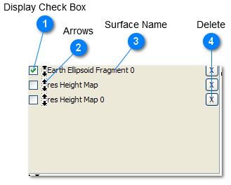
 Display Check Box
Checking this box displays the surface, which allows surveys in that coordinate space to be displayed.
|
 Arrows
Use these arrows to move the surfaces up and down in the list for management purposes.
|
 Surface Name
The name of the surface is given here. For Height Maps the name of the Survey is given as the first part of the name.
|
 Delete
Click here to delete surfaces. You do not need a separate surface for each survey so many can be deleted when you have overlapping surveys.
|