2. Overview of ArchaeoFusion
ArchaeoFusionis a software package for assembling, processing, and integrating multiple geophysical datasets collected at an archeological site. It could be used for other applications in near surface geophysics, but was designed specifically for multi-sensor archaeological geophysics. Geophysical data are collected by walking back and forth in a regular grid across the landscape, and then you take those data in their various formats and with their various problems, and fix the errors, and piece little squares of data (called "tiles") collected at different times and days and even years, into larger composite images (called "surveys"). You then work on the survey as a whole to process out other defects, match up edges, remove drift, etc., and then maybe do some image enhancement and even integrate or "fuse" the data. You can do this for a variety of data types including ground-penetrating radar (GPR), magnetometry, resistivity, and electromagnetic induction (conductivity and magnetic susceptibility). Each survey is treated like a GIS layer, and you can turn them on and off, change the order, and do a variety of fusions so you can see multiple datasets at once. You can combine magnetometry, resistivity, and a GPR slices together, for example, using supervised classification, principal components analysis, or simple addition, max function, or transparency overlays, etc.
Reasons for creating ArchaeoFusion
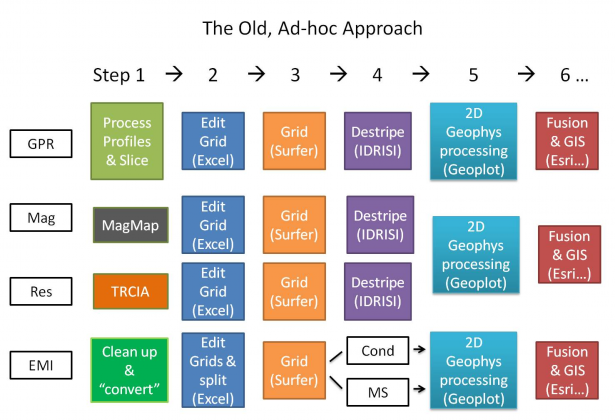
There are a variety of software packages for processing geophysical data, but no single one does them all. Prior to creating ArchaeoFusion, the program designers used a time-consuming and somewhat incompatible combination of free software provided by instrument manufacturers, and a handful of commercial software to separately process GPR data, magnetometry, resistivity, and EMI and then interpret and integrate them in GIS. Through the process of exporting, reformatting, and importing to other file formats, data integrity and metadata are lost. Figure 1 is a flowchart showing the typical steps and software products used to process multisensor data.
Figure 1. Each color represents a different software package or type of software. White represents original datasets.
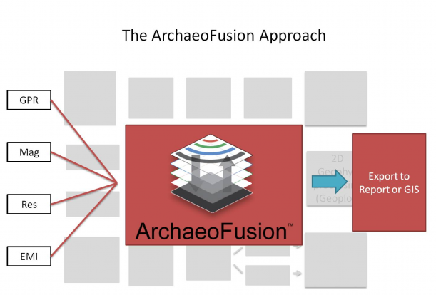
Using ArchaeoFusion, this Ad-hoc approach is replaced with a much more streamlined method, using a single software for all processing and many forms of data fusion (Figure 2). This is often all that is needed, but ArchaeoFusion also exports data as geoTIFF or data file formats that go easily into GIS software such as ArcGIS for integrating the data with other types of information from a site such as line drawings.
Figure 2. Using ArchaeoFusion streamlines data processing and integration by keeping the data in the same software environment from beginning to end. Final products from ArchaeoFusion can be exported as images for publishing in reports, presentations, and on the web, or for integration with other types of data such as line drawings in GIS or similar software.
Advantages of ArchaeoFusion
1. Working/Viewing environment allows flat 2D views as well as 3D surfaces and draping
Magnetometry data show draped over a height map of resistivity data.
2. Imports the following data formats:
-
GPR: GSSI & S&S
-
EMI: Geonics, GSSI
-
Magnetometry: Bartington, Geoscan, Geometrics
-
Electrical Resistance: Geoscan, TRCIA
-
Generic: XYZ ascii, Z-only ascii, spreadsheet ascii
-
Image: TIFF and JPEG
-
Software Spedific: Surfer Binary grid, Surfer ascii grid
-
Surface Mesh (DEM)
3. Exports Surveys as:
4. The
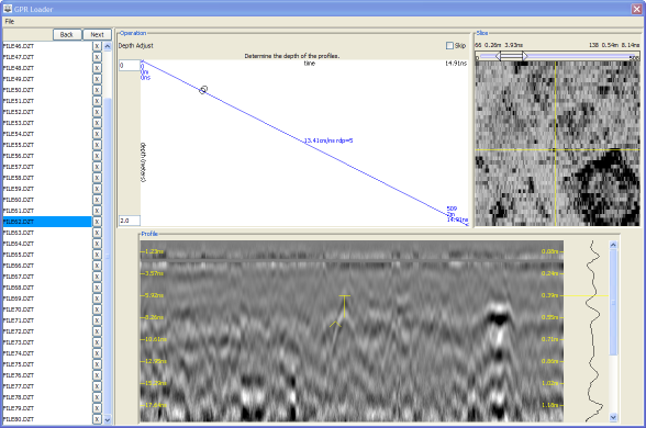
GPR Loader provides
guided GPR data processing by walking the user through step by step beginning with loading the individual reflection profiles, and including filtering, gaining, calculating velocity, and slicing. A 3D cube is created and then sliced, creating a multi-band image for processing with other 2D data. The data cubes can be re-sliced at any time.
5. GIS-like working environment treats geophysical surveys as layers that can be registered in real world coordinates and placed on top of topographic surfaces and aerial or satellite images. The ability to view all your data at once immediately gives context and facilitates interpretation as you continue to add more data and process. Separate surveys or layers and even different parts of the same survey can have a different resolutions (pixel sizes or sampling densities).
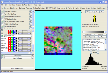
6. Data Fusion options include:
-
Band Calculator (allows any simple equation to be used between layers including addition, max, min, and product)
-
Principle Components Analysis (PCA)
-
K-means cluster analysis (unsupervised classification)
-
Red-Green-Blue (RGB) color composites
Showing a RBG color composite of magnetometry (red), Magnetic Susceptibility (blue), and GPR data that is summarized in one component from a PCA operation (green).
7.
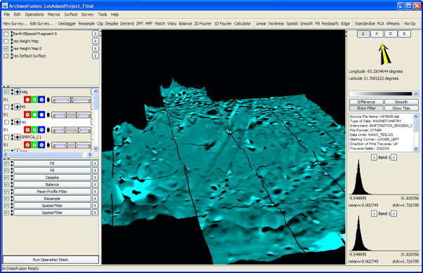
ArchaeoFusion has a fully visible and editable
Operation Stack. Each operation (processing step) used is added to a list along the left panel, and each one can be tweaked at any time to see how that will affect the final outcome. Operations can be re-ordered, temporarily turned off, or deleted. The entire stack can be saved and loaded for another survey, or sent to a colleague for their use.
8. Macros designed to process different types of data can be loaded, then tweaked to suit the specific situation. Pre-loaded macros are particularly helpful for those new to data processing and are a good starting point. A macro is an operation stack that has been created and saved, and can then be loaded and applied to any survey.